README
rsc-world-map
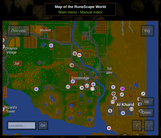
interactive world map for runescape classic.
features:
- mobile and tablet support with touch controls (still WIP)
- works with any height x width >=
300px x 300px - four levels of zoom with crisp, pixelated landscape and anti-aliased text
- overview box for quick navigation across ends of the map
- go up and down plane levels to view dungeons and upstairs areas
- search box with automatic suggestions
- toggle labels, object and points of interest
- native javascript with zero framework dependencies, just import and specify a block container element
- zero additional HTTP requests - everything packed inside the javascript
install
$ npm install @2003scape/rsc-world-map
usage
const WorldMap = require('@2003scape/rsc-world-map');

const container = document.createElement('div');
container.style.height = '300px';
container.style.width = '300px';
container.style.border = '1px solid #f0f';

const worldMap = new WorldMap({ container });

worldMap.init().then(() => {
    console.log('loaded');
});

document.body.style.background = '#000';
document.body.appendChild(container);
api
worldMap = new WorldMap({ container, labels?, points?, objects? })
create a new worldMap instance.
container is any block element.
the rest of the properties are optional, and defaulted to official runescape
classic entries (located in ./res):
labels are used for the text overlay on the map:
{
    "text": "Kingdom of\nKandarin",
    "x": 7705,
    "y": 6821,
    "size": 12,
    "align": "center" || "left",
    "bold": true, // optional
    "colour": "rgb(254, 165, 0)" || "#ff00ff" || "red" // optional
}
points are used for the point-of-interest symbols on the map. there's a list
of point types in ./res/key.json:
{ "type": "altar", "x": 7253, "y": 7272 }
the coordinates for points and labels are absolute.
objects are used for the + symbols peppered over the map:
{ "id": 0, "x": 345, "y": 538 }
the coordinates for objects are in-game coordinates from
@2003scape/rsc-data
(note that direction is not needed here). trees (id 0) are coloured green
while the rest are orange.
worldMap.init()
load the images, attach the event handlers and populate the container element.
static map images
to generate a static PNG of the world map, use the CLI tool in @2003scape/rsc-landscape
you can also use this to generate the plane-x.png images in ./res/.
license
Copyright (C) 2021 2003Scape Team
This program is free software: you can redistribute it and/or modify it under the terms of the GNU Affero General Public License as published by the Free Software Foundation, either version 3 of the License, or (at your option) any later version.
This program is distributed in the hope that it will be useful, but WITHOUT ANY WARRANTY; without even the implied warranty of MERCHANTABILITY or FITNESS FOR A PARTICULAR PURPOSE. See the GNU Affero General Public License for more details.
You should have received a copy of the GNU Affero General Public License along with this program. If not, see http://www.gnu.org/licenses/.